I had planned a good route from Divriği to Dersim before I knew that Ferda and Hacer were joining me for this section. This “good route” meant lots of dirt roads and lots of climbing. I worried it might be too hard for Hacer who went on her first bicycle tour last year on the Frig Yolu with us. This would be her second bicycle tour. However, I insisted we stick with the plan till the district capital of Kemaliye. From there we chose main roads which, though still hilly, were paved.
From Divriği it started out like this:


It was a slow climb, steep at times, on a rough (at times) road, but Hacer appears to be having fun:


In the US people may be familiar with the colorful desert of Artist’s Drive in Death Valley NP or the Painted Desert in Arizona. In Israel’s Negev I came across something called Colored Sands in the Ha-Makhtesh Ha-Gadol (Big Crater). Well, on this day, just before our drop into Dazlak on the Çaltı Çayı (a creek; Divriği is also on the Çaltı; the railroad follows the canyon; the road does not), we rode through a section of beautifully colored rocks and sands.


It was much more brilliantly colorful than my photos illustrate. Maybe it was my sunglasses, or the relief of finally going downhill, or perhaps the LSD?
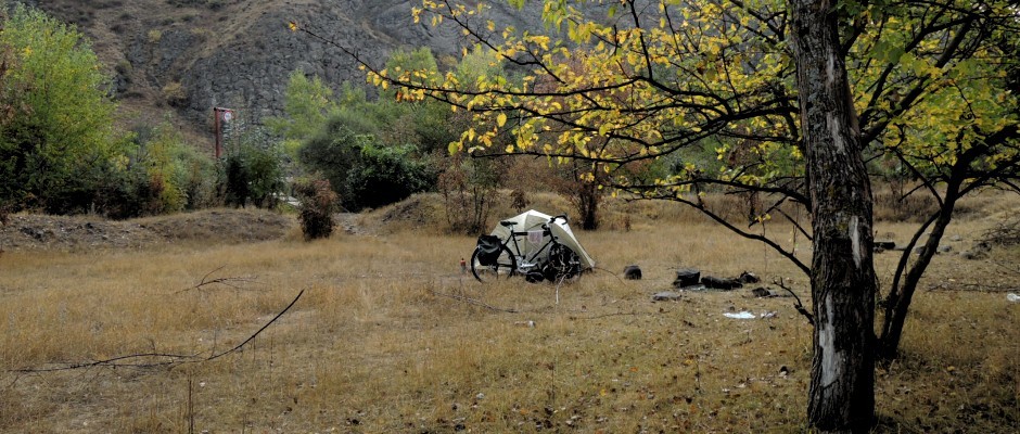
We were pleased with our campsite at Dazlak as well:


We had more fun scenery the next day.


Again it was a climb out of the Çaltı Canyon and a descent back into it, this time to Burmahan where Ali Rıza was excited to host us for a couple hours. He gave us honey, coffee, bread, apples, tomatoes, peppers, peaches. He also showed us around the dilapidated caravan saray (the place is called Burmahan after all), the largest in the region.


Of course it was up and down (again) to end up back at the Çaltı Creek (again) that night for another nice campsite.


Our climb the next morning was on a paved road which makes things go a lot faster.


This time our descent took us not to the Çaltı Creek but to the Euphrates (Fırat) River. I think this was my first ever view of the Euphrates but sadly it’s not a river at all here. It’s backed up behind the Keban Barajı, a huge dam.

What I really didn’t want to miss on this section was the chance to bicycle the Kemaliyeliler Taş Yolu (Kemaliye Stone Road). In spite of what people might want to tell you, there’s nothing historic about this road. It opened about 20 years ago, does not follow an old railroad route or any old route of any sort. It’s also not dangerous (you can easily read otherwise). It seems to be a tourist gimmick, and I figured there’d be a fair bit of tourist traffic. There wasn’t. We had the whole thing to ourselves until just before the end (near Kemaliye) when two or three cars passed. Even though the road was completed recently for tourists, all the blasted waste rock was simply dumped over the edge into the canyon which you can see a bit here:

The waste rock dumps and the stagnant reservoir water certainly do not give the place any sort of natural feel. There are open sections like I’ve shown above, but a great deal of the road is in tunnels so it looks more like this:


In spite of my complaints it was a real hoot to bicycle this road. It’s only about 8km long, half of which is in tunnels, but we ended taking 2.5 hours to ride through here!
The real bonus, however, is that the road took us to Kemaliye (aka Eğin) which certainly deserves the little attention it does get from tourists. There are many restored houses and fun-to-explore streets.


This is a restored and still working mill, but we couldn’t get inside to see the millworks.

Kemaliye is known for its decorative door knockers.

Here Ferda is showing that each door has an upper:

and lower knocker:

They make different sounds. Historically men used the upper knocker, and women used the lower knocker, and since they make different sounds, the people inside would know if it’s a male or female visitor. An old woman who proudly showed her door knocker to us explained that the different sounds are no longer necessary.
In addition to door knockers this area is famous for its mulberries. Kemaliye is where you can find lök, a helva-like sweet made from mulberries and walnuts. It was tasty. The mulberries were being harvested while we were there. I saw people in their gardens making syrup (pekmez) and fruit leather (pestil) from the mulberries. Here they are drying in the nearby village of Apçağa:

Kemaliye’s most impressive building is the old Armenian church, later used for carpet manufacturing, and later still as a prison (for Armenians?, I wonder). Last year it was used as a cafe, but it was closed this year because of covid 19. The thoughtful man at the small shop that I went to both days in Kemaliye asked me, “do you think Turks would be pleased if the US used an old mosque as a cafe?” It also distressed him that (the 6th century Christian cathedral of) Aya Sofya in İstanbul is now being used as a mosque.


We left Kemaliye on the main paved road instead of unpaved village roads, but there was still plenty of climbing.


The following morning a woman from İstanbul visiting her family in Başpınar gave us a tour of this beautiful village. Seriously, it reminded me of Swiss villages.


A bit more riding brought us to this gorge and river:

which marks the border between Kemaliye (Erzincan) and Çemişgezek (Tunceli, aka Dersim, a province we were all excited to visit).
I’d love to see this route on a map. Looks like a tour I’d live.
What temperatures? (F, please) and which month?
I wonder if I can embed flickr photos in comments like I can in the blog:
https://www.flickr.com/photos/bryandkeith/50457109983/
Well, that will either show up as a link or as a photo. We’ll see.
Yes, I think you’d really like this section though you’ll certainly want to ride in cooler weather. We were there in August, and it was probably 90F most days, cooling off enough to sleep easily at night. By myself (before Ferda and Hacer joined me) I rode mostly in the mornings, but with three of us we unfortunately rode mostly in the afternoons. Spring is probably nice as it’d be greener, and there’d be snow on the mountains.
Another fun installment! Looks great!
So nice to receive these posts from you again!